


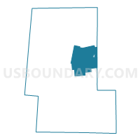
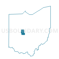
Voting District LEESBURG, Union County, Ohio
About
Outline

Summary
| Unique Area Identifier | 652860 |
| Name | Voting District LEESBURG |
| County | Union County |
| State | Ohio |
| Area (square miles) | 30.15 |
| Land Area (square miles) | 29.83 |
| Water Area (square miles) | 0.32 |
| % of Land Area | 98.94 |
| % of Water Area | 1.06 |
| Latitude of the Internal Point | 40.34170480 |
| Longtitude of the Internal Point | -83.30310570 |
Maps

Graphs
Select a template below for downloading or customizing gragh for Voting District LEESBURG, Union County, Ohio


Neighbors
Neighoring Voting District (by Name) Neighboring Voting District on the Map
- Voting District CLAIBOURNE 2, Union County, OH
- Voting District DOVER 1, Union County, OH
- Voting District MAGNETIC SPRINGS, Union County, OH
- Voting District PARIS 2, Union County, OH
- SCIOTO TWP A Voting District, Delaware County, OH
- SCIOTO TWP B Voting District, Delaware County, OH
- Voting District TAYLOR 1, Union County, OH
- THOMPSON TWP Voting District, Delaware County, OH
Top 10 Neighboring County Subdivision (by Population) Neighboring County Subdivision on the Map
- Paris township, Union County, OH (23,645)
- Claibourne township, Union County, OH (3,519)
- Scioto township, Delaware County, OH (2,993)
- Dover township, Union County, OH (2,158)
- Taylor township, Union County, OH (1,560)
- Leesburg township, Union County, OH (1,414)
- Thompson township, Delaware County, OH (684)
Top 10 Neighboring Place (by Population) Neighboring Place on the Map
Top 10 Neighboring Unified School District (by Population) Neighboring Unified School District on the Map
- Marysville Exempted Village School District, OH (30,859)
- Buckeye Valley Local School District, OH (16,331)
- North Union Local School District, OH (8,125)
Top 10 Neighboring State Legislative District Lower Chamber (by Population) Neighboring State Legislative District Lower Chamber on the Map
Top 10 Neighboring State Legislative District Upper Chamber (by Population) Neighboring State Legislative District Upper Chamber on the Map
Top 10 Neighboring 111th Congressional District (by Population) Neighboring 111th Congressional District on the Map
Top 10 Neighboring Census Tract (by Population) Neighboring Census Tract on the Map
- Census Tract 503.03, Union County, OH (6,648)
- Census Tract 120, Delaware County, OH (5,129)
- Census Tract 502, Union County, OH (4,710)
- Census Tract 503.04, Union County, OH (2,346)